Crypt Peak
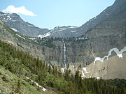
Mountain summit in Glacier National ParkCrypt Peak is an 8,579-foot (2,615 m) mountain summit located in Glacier National Park, in Glacier County of the U.S. state of Montana. It is situated along the Canada–United States border, above Crypt Lake, and is partially within Waterton Lakes National Park. Crypt Peak is part of the Lewis Range, and is approximately three miles east of Waterton Lake. Topographic relief is significant as Crypt Peak rises over 2,100 feet above Crypt Lake in approximately one-half mile (1.6 km), and 4,400 ft (1,340 m) above Waterton Lake in three miles (4.8 km). Precipitation runoff from the mountain drains west to Waterton Lake, and east to Belly River. This geographical feature's name has not yet been officially adopted by the United States Board on Geographic Names.
Read article


Top Questions
AI generatedMore questions
Nearby Places
Crypt Lake Trail
Crypt Falls
Waterfall in Alberta, Canada
Wilson Range

Miche Wabun Peak
Mountain in the American state of Montana
Sarcee Mountain
Mountain in the state of Montana
Miche Wabun Lake
Lake in the American state of Montana

Mount Boswell
Mountain in the country of Canada
Sofa Mountain
Mountain in Waterton Lakes NP, Canada